16.2 Changing Weather
16.2 Changing Weather
Lesson Objectives
- Describe air masses and how they move.
- Identify types of fronts and the weather they bring.
- Define cyclone and anticyclone.
Vocabulary
- air mass
- anticyclone
- cold front
- cyclone
- front
- occluded front
- stationary front
- warm front
Introduction
Did you ever hear this riddle?
Question: Why did the woman go outdoors with her purse open?
Answer: Because she expected some change in the weather!
Weather is always changing. One day might be cold and cloudy. The next day might be warm and sunny. Even on the same day, the weather can change a lot. A beautiful morning might be followed by a stormy afternoon. Why does weather change? The main reason is moving air masses.
Air Masses
An air mass is a large body of air that has about the same conditions throughout. For example, an air mass might have cold dry air. Another air mass might have warm moist air. The conditions in an air mass depend on where the air mass formed.
Formation of Air Masses
Most air masses form over polar or tropical regions. They may form over continents or oceans. Air masses are moist if they form over oceans. They are dry if they form over continents. Air masses that form over oceans are called maritime air masses. Those that form over continents are called continental air masses. Figure below shows air masses that form over or near North America.
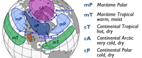
North American air masses.
An air mass takes on the conditions of the area where it forms. For example, a continental polar air mass has cold dry air. A maritime polar air mass has cold moist air. Which air masses have warm moist air? Where do they form?
Movement of Air Masses
When a new air mass goes over a region it brings its characteristics to the region. This may change the area's temperature and humidity. Moving air masses cause the weather to change when they contact different conditions. For example, a warm air mass moving over cold ground may cause an inversion.
Why do air masses move? Winds and jet streams push them along. Cold air masses tend to move toward the equator. Warm air masses tend to move toward the poles. Coriolis effect causes them to move on a diagonal. Many air masses move toward the northeast over the U.S. This is the same direction that global winds blow.
Fronts
When cold air masses move south from the poles, they run into warm air masses moving north from the tropics. The boundary between two air masses is called a front. Air masses usually don’t mix at a front. The differences in temperature and pressure cause clouds and precipitation. Types of fronts include cold, warm, occluded, and stationary fronts.
Cold Fronts
A cold front occurs when a cold air mass runs into a warm air mass. This is shown in Figure below. The cold air mass moves faster than the warm air mass and lifts the warm air mass out of its way. As the warm air rises, its water vapor condenses. Clouds form, and precipitation falls. If the warm air is very humid, precipitation can be heavy. Temperature and pressure differences between the two air masses cause winds. Winds may be very strong along a cold front.

Cold fronts often bring stormy weather.
As the fast-moving cold air mass keeps advancing, so does the cold front. Cold fronts often bring sudden changes in the weather. There may be a thin line of storms right at the front that moves as it moves. In the spring and summer, these storms may be thunderstorms and tornadoes. In the late fall and winter, snow storms may occur. After a cold front passes, the cold air mass behind it brings cooler temperatures. The air is likely to be less humid as well. Can you explain why?
Warm Fronts
When a warm air mass runs into a cold air mass it creates a warm front. This is shown in Figure below. The warm air mass is moving faster than the cold air mass, so it flows up over the cold air mass. As the warm air rises, it cools, resulting in clouds and sometimes light precipitation. Warm fronts move slowly and cover a wide area. After a warm front passes, the warm air mass behind it brings warmer temperatures. The warm air is also likely to be more humid.

Warm fronts generally bring cloudy weather.
Occluded Fronts
With an occluded front, a warm air mass becomes trapped between two cold air masses. The warm air is lifted up above the cold air as in Figure below. Cloudy weather and precipitation along the front are typical.

How does an occluded front differ from a warm or cold front?
Stationary Fronts
Sometimes two air masses stop moving when they meet. These stalled air masses create a stationary front. Such a front may bring clouds and precipitation to the same area for many days.
Cyclones and Anticyclones
Cold air is dense, so it sinks. This creates a center of high pressure. Warm air is less dense so it rises. This creates a center of low pressure. Air always flows from higher to lower pressure. As the air flows, Earth’s surface rotates below it causing Coriolis effect. So while the wind blows into the low pressure, it revolves in a circular pattern. This wind pattern forms a cyclone. The same happens while the wind blows out of a high pressure. This forms an anticyclone. Both are shown in Figure below.
- A cyclone is a system of winds that rotates around a center of low pressure. Cyclones bring cloudy, wet weather.
- An anticyclone is a system of winds that rotates around a center of high pressure. Anticyclones bring fair, dry weather.

In the Northern Hemisphere, cyclones rotate counterclockwise and anticyclones rotate clockwise. This is the reverse in the Southern Hemisphere.
Lesson Summary
- An air mass is a large body of air that has about the same conditions throughout. Air masses take on the conditions of the area where they form. Winds and air currents cause air masses to move. Moving air masses cause changes in the weather.
- A front forms at the boundary between two air masses. Types of fronts include cold, warm, occluded, and stationary fronts. Clouds, precipitation, and storms commonly occur along fronts.
- A cyclone is a system of winds that rotates around a center of low air pressure. An anticyclone is a system of winds that rotates around a center of high air pressure.
Lesson Review Questions
Recall
1. What is an air mass?
2. Describe continental polar and maritime tropical air masses.
3. What causes air masses to move?
4. What is a front?
5. Define cyclone and anticyclone.
Apply Concepts
6. Create an original diagram to represent an occluded front. It should include weather conditions along the front.
Think Critically
7. Compare and contrast warm and cold fronts.
8. The weather report states that your town is under a stationary front. You look out the window and see rain. Predict what the weather will be like tomorrow. Explain your prediction.
Points to Consider
Remember the tornado on the first page of this chapter? Tornadoes usually occur along cold fronts.
- Tornadoes are one type of storm. What are some other types of storms?
- Tornadoes usually form during severe thunderstorms or hurricanes. Do you know why?
- Log in or register to post comments
- Email this page